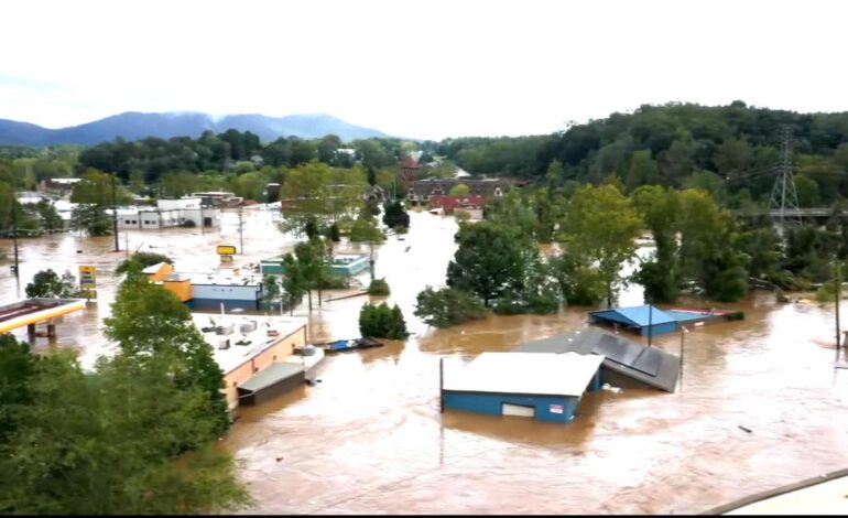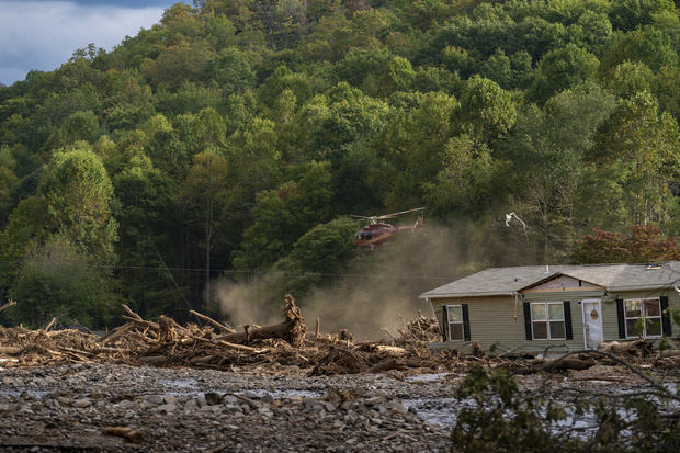
Hurricane Helene has proved to be disastrous for Appalachia, as massive amounts of precipitation from the storm caused rampant flooding that has devastated several towns and killed dozens of people. On Monday, the North Carolina State Climate Office provided a picture of how the “monster storm” was nearly a “worst-case scenario for western North Carolina.”
“Torrential rainfall from the remnants of Hurricane Helene capped off three days of extreme, unrelenting precipitation, which left catastrophic flooding and unimaginable damage in our Mountains and southern Foothills,” a post from the office says. “… the full extent of this event will take years to document – not to mention, to recover from.”
Here’s how the climatologists said it happened.
North Carolina was saturated with rain before Helene hit
As Helene became a Category 1 hurricane in the Gulf of Mexico — more than 500 miles and 30 hours away from where it would eventually make landfall in Florida — western North Carolina was already seeing rain. The climate office says that Helene’s outskirts were feeding tropical moisture to slow-moving storms that had formed along a stalled cold front.
By midnight on Thursday — roughly an hour after Helene’s landfall 10 miles north of Steinhatchee, Florida — Asheville Airport in North Carolina had already seen more than 4 inches of rain. That downpour continued before Helene’s outerbands even moved in. By Thursday night, Yancey County, which sits just south of Erwin, Tennessee, where floodwaters became so bad that people were trapped on the roof of a hospital, had seen more than 9 inches of rain.

Water was already beginning to inundate cities, “all while the heaviest rain from Helene was just beginning to fall,” the climate office said. The more than 300 miles of tropical storm-force winds Helene produced only amplified the situation, pushing more moisture up mountains.
“The storm’s impacts were especially long-lasting because of its massive size. It developed in a high-humidity environment over the warm Gulf of Mexico, which let it grow and strengthen unimpeded,” the office said. “…From the start of the precursor frontal showers on Wednesday evening to the heart of Helene moving through on Friday morning, it was one of the most incredible and impactful weather events our state has ever seen.”
Record rain brings reports of “biblical devastation”
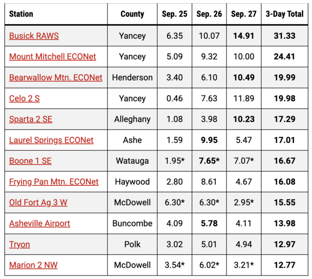
From Wednesday to Friday, the office said that there were more than 8 inches of rain across the western North Carolina mountains, with some areas seeing a foot or more. The highest rainfall total was in Busick, with a three-day total of 31.33 inches — more than 2.5 feet.
At least a dozen weather stations recorded their wettest three-day periods on record, the office said. Asheville Regional Airport lost communications on Friday morning after Helene’s landfall, but had already reported just under 14 inches of rain. That amount, the office said, was “nearly three months’ worth of precipitation … in less than three days.”
All of that rain caused rivers to flood, landslides and mudslides, leading to rescues across several counties.
In Buncombe County, home to Asheville, Emergency Services Assistant Director Ryan Cole told the Citizen-Times that “catastrophic devastation” didn’t accurately describe the impact the deluge had.
“It would go a little bit further and say we have biblical devastation through the county,” Cole said. “We’ve had biblical flooding here and it has been extremely significant.”
The newspaper quoted county manager Avril Pinder as saying, “this is looking to be Buncombe County’s own Hurricane Katrina.”
“Helene brought the full suite of hurricane impacts to North Carolina,” the climate office said, “and in full force just hours after its landfall at Category-4 strength.”
The winds from Helene were felt across western North Carolina, with the Charlotte Airport recording the strongest wind gusts it’s seen since a thunderstorm microburst in August 2019. The winds, which surpassed hurricane speeds in some places, contributed to widespread power outages. Millions were left without power across several states because of Helene, and as of Tuesday morning, hundreds of thousands remain without electricity in North Carolina alone.
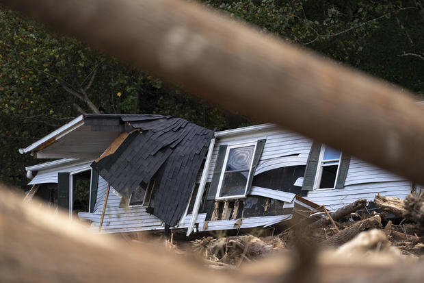
On Wednesday evening, as the state battled existing storms ahead of Helene, a rare mountain tornado formed in Watauga County, the first it had seen since 1998. The day after Helene made landfall, at least six tornadoes were confirmed, including an EF3 in Rocky Mount that destroyed several buildings.
A historic and deadly storm
CBS News has confirmed that at least 162 people across several states were killed by Helene. Buncombe County alone has reported more than 50 deaths, including a 7-year-old who was swept away by floodwaters with his grandparents.
While hundreds of people were able to be rescued, there have been even more requests for welfare checks. And given the severity of the damage, the climate office said that suggests “the death toll is likely to climb as hard-hit areas are finally accessed in the coming days.”
“Sadly, our state’s long-running benchmark for deaths during a tropical event — approximately 80 during the mountain region’s July 1916 flood — could be in jeopardy from this storm that has already broken plenty of other records,” the climate office said, adding that the 1916 event was the area’s flood of record for more than a century — a title that “now belongs to Helene instead.”
Several rivers surpassed their highest-ever crests by several feet, including the Swannanoa River, which saw “the worst flood along the river since North Carolina became a state,” the office said.
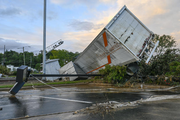
As unprecedented as Helene’s impact on the region was, there is a chance it won’t be the last.
“The rapid intensification of Helene over the Gulf, the amount of moisture available in its surrounding environment, and its manifestation as locally heavy — and in some cases, historically unheard of — rainfall amounts are all known side effects of a warmer atmosphere,” the office said.
Last year was already the warmest humans had ever recorded and 2024 has seen countless heat records. The continued use of fossil fuels releases greenhouse gases that are trapping heat within the atmosphere, increasing average temperatures that fuel extreme weather events like Helene.
It’s unclear when an event like Helene would downpour on Appalachia again, but the climate office is near-certain about one thing: “We won’t see another Helene in the Atlantic.”
Officials often retire hurricane names when they are particularly devastating, and while such action has yet to be announced, the climatologists suggest it may only be a matter of time.
- Japanese man who married virtual character now on a mission to educate others about ‘fictosexuals’
- South Korean milestone as married lesbian couple welcomes first child via IVF
- Watch: Vlogger tours ‘Japan’s worst tiny apartment’
- Young Japanese are now saying ‘I do’ without love, sex in ‘friendship marriages’
- Discover the Mediterranean with flydubai

